A Day in the Life of a Civil Engineer – Day 28

Day 28

Utility in our Right of Way with No Permit

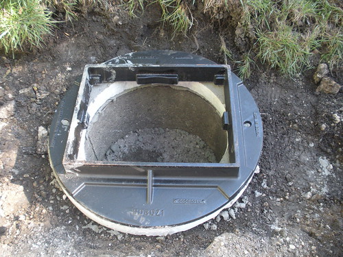
Today I spent a little more time looking into the utility that was placed in our right of way with no permit. We went out into the field to measure how far off the road the concrete handholes were poured. For most of the length, the road has a rural section (no curb and gutter – only gravel shoulders). The edge of the concrete was 9", 12", and 18" from the edge of pavement at the three handholes. 

After looking into the property documents in that area, I also realized that the owner of the utility owns land north of the roadway so at least a quarter mile of the line could have been placed further off the road on their own property. Also, about another quarter mile was placed along right of way that is only for the use of roadway – not utilities. This is a common mistake unfortunately made by engineers who do not understand property ownership. What the engineer missed here is that in rural areas most land owners with property adjacent to roadways actually own to the center of the road. And the owners have given an easement to the public for roadway purposes only. So if you are designing a utility  like water mains or sanitary sewers and plan to have them installed in this apparent "right of way," you still need to arrange for the property owner to grant an easement for the utility because it has no relationship to roadway use. Of course, my supervisor and other staff members in our office realized this, but the consultant designing this project must not have.

So, I am not yet sure how this will all be resolved. We have set up a meeting to discuss it further.
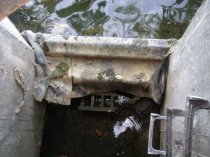
Looking down on a weir in a restrictor

People Messing with Drainage

So after gathering more information about the permit issue, I spent some time with other staff members looking at a restrictor structure where someone had altered the height of the overflow. We aren't sure when this happened and only realized it after residents started complaining about failed flared end sections. One of our staff members figured it out by researching the subdivision plans which were dated in the 1970s then arranging to have some elevations taken on the structure. Through his efforts, he determined the height had been raised by about 6 inches which makes sense because as you look around the pond, each end section is submerged by about 6 inches. The person who raised the weir seems to have done so by trying to first use concrete blocks and then placing wood wrapped in a rubber membrane. You can see the result of their work in the photo to the left. This is a view looking down from the top of the structure. After a few of us visited the structure today, we came up with a solution of cutting the wood down to the design height. This allows us to quickly resolve the situation with minimal cost and disruption. We still are surprised that someone would take it upon themselves to raise the design level of a retention pond in a subdivision.

Inlet Removal and Replacement

Later in the day, I met with a contractor who was going to pave around an inlet we removed and replaced earlier in the year. We had done this to help encourage water to flow into this inlet rather than continue to travel down the road and down properties lying adjacent to and sloping away from the roadway. Unfortunately our work will not allow for the capture of all the water flowing down the road and onto the properties. But since the properties along the road slope down from the road at a significant grade to a creek, there's only so much we can do to keep the water completely on the road.

Developments and Parking Lots

At the end of the day I had the opportunity to participate in a discussion with a developer about some property in our city. It was a great meeting, and because the developer knew a lot about our city, I was able to learn many things. Later in the evening, one of our staff engineers and I attended a planning commission meeting. The group was considering our request to change zoning on a specific parcel in our downtown and allow for the use of a parking lot in that same block. After the project engineer testified and explained our project, the commission asked questions about the project then approved our request. This will now go forward for council consideration and hopefully approval.
Share

A Day in the Life of a Civil Engineer – Day 15

Day 15

GIS Maps

Yesterday at the very end of the day, our IT staff added a link on our Intranet site to the web map we had created. This is an online map of our GIS information that's accessed through a browser. Unfortunately we still haven't been able to make the web map in the Silverlight Viewer, so we instead put up the one we made with the default ArcGIS web map application. The map we published is only a beta version, and we are using it to find out what everyone thinks of the format and information. Over the next few weeks we will get feedback from users and incorporate their ideas into a new map. We've already had some great input!

The other task that our IT was able to take care of was getting us access to the county's internal GIS map. We added that link also because it will be a great resource for our users. We are so lucky in Kane County to have a great GIS staff at the county level. They are never too busy to talk to us about their GIS or data, they hold regular meetings of GIS users in the area, and they are so helpful when we have questions about anything.

Storm sewer project

I reviewed the storm sewer project design that our interns finished up. And because we need an easement from the property owner, I wrote a legal description for the easement. Now, we'll give it to the homeowner for his attorney to check and if ok, prepare the necessary documents. We ask homeowners to get the easements drawn up for us if they are the ones requesting a sewer to alleviate their drainage problem. And the city has only done this if the problem is significant and affects multiple properties. In this case the problem meets this criteria so if they can provide the easement the city will install the sewer.

Intern's Last Day

Today was the last day for one of our interns. He is returning to school next week. So we took both interns out to lunch. They both have done a great job helping us with numerous projects. I think they learned a lot of things that they normally would not pick up in school.

Research Property Records

The city is considering selling some of its property so we are researching the legal documents and making sure there are no restrictions on selling the property. Today I went over some more of the documents, verified our ownership, and went to the courthouse to get copies of some of the deeds. 

Grant for Road Work

The city has also received word that we are going to get a grant. So today I was able to talk to our grant liason at DCEO who helped us understand what we could use the property on. Now we need to fill out the paperwork and submit it for approval. This is something I plan to work on next week.

Plan Review

Last week, I received a re-submittal of plans for a development project in our community. So today I started going back through my comments to make sure they had addressed everything. Because I didn't have a chance to finish, I will work on them again next week.

Share

A Day in the Life of a Civil Engineer – Day 8

Day 8

Geneva Road Construction Aug 2011

The great construction mystery: Why aren't the standard frames made to fit the standard inlets?


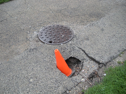
Well, the inlet frames I picked out were placed on the structures today! I went out to work with the crew while they were placing them to make sure they fit and they were set at the right elevation. (If you've been reading my blog, you'll remember I had to buy special grates to fit the inlets because the old ones were too big.) While we worked, we discussed how the frames and grates that are in the IDOT standards do not fit the inlet structures that are in the standard. Which really doesn't make sense. But the worst part of it is this causes a gap where dirt and road base are washed out from under the road into the inlet. This ends up leaving a big hole near the inlet or manhole.  (You can see an example of this in the photo below.) And these failures can end up being the biggest maintenance problem I see cities dealing with. Where I worked before the 

Chicago 2011 Photos near Lincoln Park Area

contractors were good about working with me to avoid problems by pouring a lot of concrete around the inlet frame to seal it. But up here where I work now, they don't seem as interested in cooperating, and I'm not on the job as much to make sure they are doing it. So one of our water guys told me he found an inlet frame he thinks fits better so I am going to check out what he has picked out, and if it works, we will spec that for the job next year.


Parking Lot Project

We are still working on our new parking lot design. Today I finished up the ownership information and emailed it to the city attorney. The project engineer and I also discussed our approach to applying for a special use permit. In this city, we are not exempt from our own regulations so our department must apply to the community development department asking for the planning commission and city council to approve a special use for the lot. 

APWA Education Committee

I also participated in a phone conference with the APWA education committee for the Chicago Chapter. They are planning some pretty cool sessions. My role in the conversation was only to discuss the possibility of giving a presentation on communication and social media. 

Certificates of Completion for Development

Another task for which my office is responsible is preparing certificates of completion for new developments. So today I prepared and submitted to the city council for consideration a certificate of completion for one of the new developments in our city. The process works like this: when everything is finished, our inspector does a final walk through, and if everything is ok and completed, he gives us the go ahead to submit this certificate to the city council for approval. However, approval of this certificate does not mean approval of the improvements. That's another certificate we submit for approval after a specific time period has passed. 

New Developments

We also have been reviewing a new development that had been given approval to begin construction of a portion of the proposed development. And today we dedicated some time to processing and helping move forward another phase of this development.  Normally a developer would submit plans and documents and only begin construction once all approvals and payments are in place. But because some developers are more anxious than others to start doing something, it seems that occasionally we get a few that push to have us proceed in this phased approval approach. The problem is it sets up a very challenging and difficult process for us. It ends up taking a lot more staff time to respond and monitor each phase, and it creates confusion between departments as everyone struggles to keep track of what has been approved, started, paid for, etc. Anyway we want to do as much as we can to work with people investing in our community so we try to accommodate developers to help them meet their schedules. So we worked this morning to get them through the next step in the process.

Railroads and Bike Trails

We have been working on a plan to extend a bike trail along an old abandoned railroad bed. But the challenge has been we only own a portion of the property needed for the trail; the railroad still retains ownership of most of the remainder. A while back we met with a representative from the railroad who said he would work with us to investigate the possibilty of transferring ownership of their portion. But he needed a map and some other documents. So today I worked a little on getting the map prepared.


Share

A Day in the Life of a Civil Engineer – Day 1

So many people seem to have no idea what civil engineers do each day. Is this because civil engineers typically avoid promoting their work and profession? Or is this just something that people are not taught in school? Or does anyone, other than engineers, really care? Or is it a little of all of that? In an effort to help contribute to removal of the first reason, I decided to try out documenting each work day with a short summary of what I did that day working as a city engineer at a municipality with a population of approximately 23,000. I will try to avoid specific names because they should not be relevant, and because the people involved might not want this information publicly posted on a blog. Feel free to post in the comment area any questions or ideas related to the post for that day. If something is posted that reminds you of a similar experience, I'd love to hear it!


Day 1 

My normal work day starts at 7 am and officially ends at 4 pm. Usually I hang around after 4 and leave between 4:30 and 5 pm unless I have another obligation. Today, I started my day as I normally do checking my calendar and my email. Our division had received an offer from a contractor to inspect a product that we had not yet used in our city. The inspection trip was scheduled for today, so we finalized the time and who was going to go during the early morning. While waiting for the contractor to show up, I worked on the following items:

  • Finalizing the property research our interns had completed to determine property ownership in a block where the city is designing a new parking lot. We need to know the property owners because the city attorney must use this information to prepare related agreements and easements.
  • I also worked with our interns to explain how to perform and document research to determine a chain of title of property for a detention pond in one of our subdivisions. 
  • I reviewed a development plan scheduled to be discussed later that day.
  • And of course, I read through and answered and organized the day's email.

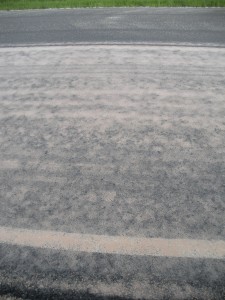
CAM Product Road TreatmentDuring the last half of the morning, some of our staff went with a contractor to inspect the performance of his product. We were also able to witness the company in the process of placing the product along a county road. Many of the products we use have been around for a long time and have a long track record. In order for us to incorporate newer products into our designs, we need to spend the time to make sure they are worth the money and will perform. In this case, we thought the product greatly improved and enhanced the performance of the pavement to which it was applied. So we agreed the product does seem to provide value at a reasonable cost. (You can see how the product looks right after its application in the photo to the left. The pavement at the top of the photo shows how it looks after it has dried.)

We ended up only stopping for a short lunch then returning to attend a staff review meeting for a proposed development. These meetings include members from all departments in the city who are part of the development review team. The purpose of the meeting is to talk about the submittal and identify any concerns or areas requiring changes or clarification. So, we discussed the proposed plan and developed comments to send to the developer. 

After the meeting, another engineer and I left the office to inspect a drainage inquiry. Questions about drainage are the most common call our division receives from residents. In this case, the person was asking about their backyard flooding. After looking up the original subdivision plans, we realized the back yard of this residence is part of a detention basin. The area is designed to flood, or detain water, during a storm. After the storm, the water will eventually drain away. The last time it rained was a few days ago, so today, the area was dry.

I also ended the day touching base again with our interns about their property research. They had discovered the basin was owned by an association affiliated with the subdivision. So I showed them how to verify the corporation and ensure it had not been dissolved and explained how to look up articles of incorporation.

There were many miscellaneous items I addressed over the day through email although I'm not sure how detailed I should be about these. For now, I'll try a short listing of some of the items, but if this seems to be too much to include in a summary, let me know:

  • Reviewed a request to hold an event in our community to ensure there were no engineering-related issues with the event request
  • Worked on getting access for our staff to the ACE11 Virtual event
  • With the help of the county staff, resolved a question about who maintains cattails in the right of way of the county road in our community
  • Passed along striping requests to one of our staff members who is managing the striping operations for this year
Share

Geneva’s Great Land Adventure

Geneva Land AdventureSeveral months ago, I read some blog posts about frustration with Gov 2.0 not doing enough and a few other posts with offers from people interested in working for free for experience. The two seemingly unrelated topics got me wondering: How could our city use Gov 2.0 to offer job opportunities to people just looking for experience and also offer opportunities to citizens interested in participating in government? My thoughts drifted to the projects I’m working on at my job. And I wondered if our city could reach out to these people with the use of Gov 2.0 tools to help us complete some of our projects. One particular project rose above the others as a perfect candidate – the creation of a database documenting all properties in which the city holds some interest. It seemed possible because all the research could be done online by anyone with a connection to the Internet.

Fortunately, my supervisor and city administrator were fully supportive of implementing this idea. And even better, an intern working for us who is a public administration graduate student was able to partner with us to set it all up. While we were planning the project, I noticed a post on GovLoop written by Dave Briggs: The need for micro-participation. It seemed to discuss exactly what we were hoping to do. His post and support of the idea of micro-volunteering inspired me to finish setting up the project. After it was complete, we took some time evaluating it. After getting some great input from everyone, the project became an adventure of discovery with a Viking theme complete with a Viking figure donated by our wastewater division staff. Now anyone can join us on a discovery of property. And people can even earn titles and rewards as they successfully complete documentation of areas. You can check out the site here: The Geneva Land Adventure.

While we realize this approach has been used before to crowdsource genealogy databases, we’re not sure if other local governments have offered similar opportunities for micro-participation. We would be interested in hearing from others who might be aware of similar examples of participation or information about property management systems already in place. And we would love to hear comments or suggestions for improving the project and would love it even more if you signed up and participated in our adventure! (And because property management in local government is not a widely discussed or known topic, I offer a little background below.)


A INTRODUCTION TO PROPERTY MANAGEMENT FOR LOCAL GOVERNMENT

People are usually surprised to discover that local governments have a significant number of interests in real estate or property. These property rights can be held in the form of deeds, dedications, easements, rights of way, or licenses. And, depending on a government agency’s size, the number of documents conveying these rights can range from hundreds to thousands.

What also surprises people is that agencies most likely do not have a property database in place to document and manage the property rights associated with these documents. When I started working at the city of LaSalle in 1993, I figured they didn’t have this in place because they were somewhat of a small community with a population of about 9700. So I got to work building the database and putting a management system in place. By the time I left in 2009, I had discovered about 300+ properties in which the city had some ownership right. What I’ve since realized from talking to others in government is that many cities lack a property database.

Based on my experience in LaSalle, I have developed a process of building the database and putting in place a management system. One of the first steps is to discover all the documents in which an agency has property rights. But this task can take significant time. Since starting a new job with the city of Geneva two years ago, I’ve been working on setting up the system here. Fortunately we already have most of the property held by deeds in a database created by the county tax assessor. But this information needs to be verified and all the other documents covering easements, licenses, dedications, etc. need to be discovered.

Some might wonder if it’s so much work, why bother. Well, in government, ownership and property rights come up frequently throughout the day. Most activities that go on in local government, particularly in public works or property maintenance, involve the need to know what can be done where. If a database does not exist, research must be done each time a question about rights or ownership comes up. With a completed database and GIS, the answers are much more readily available. There are other benefits, but to keep it brief, the bottom line is having the database saves time and money which is always a good thing to achieve in government.


Share