A Day in the Life of a Civil Engineer – Day 12

Day 12

Another GIS Day

Today ended up being another day primarily spent on GIS. I successfully was able to start a web service for some of our data. But when I went into the ArcGIS Silverlight Viewer Map Builder and put my URL into that data, it could not connect. I tried to look through the documentation to figure out why it isn't connecting, but could find nothing wrong. Our other GIS person is going to look it over too. If we both can't figure it out, I guess we'll try asking the person in our neighboring community for some help. Or maybe we'll end up calling ESRI support.  

We also worked on populating data and planning the organization of data in a few of our feature classes. This has been an ongoing task for us as we move through each type of data collected and managed by the city. Eventually I want to capture it all in a data catalog so we have a better idea of just what we have an how it is organized and who maintains it. But that's a huge project that we only have time to work on every now and then.

Grant Meeting

Today we also met to discuss a grant that was awarded to our city by the state. We needed to look through the forms that must be filled out, and we wanted to further discuss the project related to the grant. I contacted the grant administrator to get more information before we get too far into filling out everything that we must submit. But I did not yet hear back so hopefully will tomorrow so we can get going on submitting the information.

Storm Sewer Project

Our interns are still working on the CAD drawing for the small storm sewer project they are designing. It's been great experience for them to take a project from the start to finish. They have done all the field work, communication with the residents who will be impacted, the design, and the drawing of the plan. Eventually, I will have them figure out some quantities even though we will probably build this in-house.

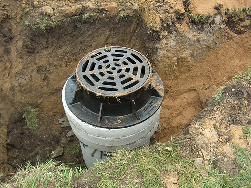
Metal Manhole Frame with concrete rings

Manhole Frame Demo

We also sat through a demo of a new type of frame and adustment system for manholes. This company was out of Canada, and their product is made entirely of rubber. Of course, being a conservative engineer, I am always skeptical at first with new products. Sometimes I find something new that does look worth trying. But in this case, I was mainly turned off by the cost. Purchasing the frame and adjusting rings was almost the same cost as buying a whole new manhole structure with the metal frame and concrete adjusting rings like the one shown in this photo. So it would be hard to justify. Plus it looked like the installation could be time-consuming which might make the total construction cost even more. It's still good to evaluate new products just to make sure we are making the best use of our funds.

Share

A Day in the Life of a Civil Engineer – Day 11

Day 11

It's all about GIS

Today was one of those days when I try over and over to work my way through a problem. Following up with how I ended on Friday, I went back to the ArcGIS Silverlight Viewer and tried to make a map. One of the first items I attemped to do was add some of our data – after all what good is the map if there's no information on it. So to do this, I had to go into our ArcGIS Server software and create what is known as a "service." Basically I think of this as setting up a pipeline between the map and some specific data that allows the data to be displayed on the map. That is a very simplistic view of it, but hopefully it gives an idea of what I was attempting to do.

The software makes it fairly easy to go through the steps. The problem was it didn't work when I was done. Another GIS person in our office tried to with different types of data, and it still would not work. We suspected it was a permission problem with the folder where the data was stored. We thought sharing the folder might help make this work. The only problem was we could not get access to the ability to set it to a shared folder. So we let our IT people know about this – they couldn't understand why we could not do it because they thought we were set as administrators on the server. But by the end of the day, they had fixed our access issue and now we are true admins on the system! So while I was excited about having the administration thing all worked out, I could not go back and test it on the map. All I had time to do was to go in and share the folder so tomorrow, we will try again publishing the service.

The other major task I worked on today was hosting our GIS Team meeting. This is a meeting we hold once a month where all major GIS users from all city departments come and share what they are doing, the challenges that have come up, training they attended or know about, or problems they need help solving. It's always a great meeting, and everyone offers great ideas.

So the day was completely devoted to GIS with the exception of a few engineering-related issues that came up. Based on all the work I'd like to get done related to GIS, I could use about 6 more months of days like today!


Share

A Day in the Life of a Civil Engineer – Day 10

Day 10

Today was a great day – well most days are pretty good, but a lot of really good things happened today! There were some minor tasks I took care of like arranging for our interns to help out the water/sewer department by shooting some elevations for a sump pump line they were repairing and working a little with the interns on the small storm sewer project they are designing. But the main focus of the day were the following items:

Inspection of Storm Management Activities and a Quick Explanation of Special Service Areas

For some time now many urban areas have been requiring new developments to address stormwater management to minimize flooding and improve water quality. So developers installed features such as detention and retention basins, wetlands, or other facilities to meet these goals. Although they have worked well over the years, the challenge that has evolved over time is the maintenance of these areas. Over the years, weeds grow up and cattails take over. Eventually the facility may no longer function as intended.

Hummingbird Moth

We have one large stormwater facilitiy within a subdivision in our city that over the years was increasingly neglected by the property owner. Fortunately our city requires all developers to either create special service areas (SSA) for these facilities or agree that in the future an SSA could be set up. The SSA works by allowing the city to assess real estate taxes on the parcels lying within the SSA for the purposes stated in the document creating that area. In most cases management of stormwater facilities is an approved use of the funds collected through an SSA. If no management is needed because the property owner or homeowner's association is taking care of it, then no taxes are assessed. However if no maintenance takes place, as in this case, the city begins assessing and managing the facility.

So earlier this year we began assessing taxes for this area and secured a contract with a design/build firm to design and implement a management plan for the area. Today our consultant took us out to inspect the work that has been done. I took many photos of the area, and you can see these on the city's Flickr site at this URL: http://www.flickr.com/photos/cityofgeneva/sets/72157627294641145/

I did add one photo here that was taken by Karen Kase, one of the employees with the consulting firm. (I asked and received permissoin to use her name and photo in this post.) She is an amazing woman – she completely understands this type of work, works hard to achieve results, and does a great job communicating to clients what has been done and what is planned. Anyway, she took this photo one day while she was working on site. She said it is a hummingbird moth. I just had to include it here in this post because it is one of the most incredible photos I have ever seen. She took it with her iphone!

Public Works Staff Meeting

We also had a public works staff meeting today. This is a meeting we have every month that includes all the superintendents and managers in our department. It's interesting and helpful to get together like this to share what each of us is doing and it helps us better coordinate our efforts. We learned that the Emerald Ash Bore has had a devastating impact on our community with thousands of trees left dead. Our street department has a forestry division, and they have been taking down all the trees in the right of way. So far they have removed 225 trees just since May of this year. The superintendent figured he could have about 2,600 more to go. Another interesting bit of information shared is that he was asked to put a sign up at the pay station for our commuter parking garage that says "US Currency Only" because people are paying with coins from Chuckie Cheese and Disney. I figured our dollar was devalued but didn't think it had gotten that low!

ArcGIS Viewer for Microsoft Silverlight

Today I also signed up for the ArcGIS Beta Community so I could get access to try out this awesome application for making web maps. The GIS person in our neighboring community who is just outstanding at creating GIS applications showed us a demo of it at our last group meeting. This application allows you to create a web map through a very easy method. And the resulting map is presented in a very nice user interface. I would highly encourage anyone interesting in creating web maps to join the Beta Community and try out this application. Anyway, I was able to get it installed by the end of the day and look forward to trying it out next week!

Share

A Day in the Life of a Civil Engineer – Day 7

Day 7

Night Meeting for the Downtown Master Plan

Geneva Downtown on State Route

I'm late getting this post up because I attended a meeting of our Downtown Master Plan Committee. We are in the process of having a plan prepared for our downtown area which is a big deal for us because we have such an awesome downtown and want to make sure it stays that way. My main input to the plan is more on issues related to engineering such as traffic and infrastructure. Tonight we discussed the 33 areas that were targeted for potential redevelopment within the study area. But at the end we also talked about one of the main routes through our downtown. It's a four-lane state route with approximately 20,000+ ADT and diagonal parking on both sides. We have sidewalks on both sides that are about 10 feet wide abutting buildings constructed to the street line. The point of discussion was that our planners have gotten feedback that people feel uncomfortable walking along this road. However our records show minimal accidents in this area, (see photo on left) particularly related to the parking or pedestrians. But the planners felt they had to address these concerns and suggested some alternatives to the section. One of the designs had some of us concerned about the possible result of losing major amounts of parking for the sole purpose of picking up a few more feet of sidewalk with no proof of an increase in safety. 

Based on my experience with walking these routes regularly at night, people can't feel too uncomfortable because this busy route is always filled with people walking or congregating on the sidewalk. And that's one of the things we really like about the area. There's always so many people walking everywhere downtown – even on this busy route. As someone who has not lived here long, I think the reason people say they don't like the busy route as much is because the other main route through our downtown is a unique and charming roadway with five-foot sidewalks, a grass parkway, and buildings set back about 25 feet or more (see example of this part of our downtown below). It's hard for any other downtown road to compete with that one. And adding a few more feet to a traditional downtown sidewalk is not going to transform it into this other type of street environment. But the planners are convinced it will make all the difference in the world. While for us engineers we cannot justify negatively impacting the traffic to increase the perception of a nicer looking road.
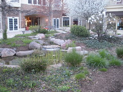
Stream and pond in downtown Geneva, IL

And in a way, taking that stand is a little ironic for me because if you read my blog regularly, you know I am somewhat anti-car. Not that I hate them or anything; I just feel they are in their decline as a mode of transportation. The more I read and the more I consider the future of transportation, I am convinced we are on the brink of beginning the transition to a new system – one made up of something along the lines of PRTs co-existing with rail, bicycles, and pedestrians.  And I start to wonder each time I design and build something for cars, just how long a life it really has. So part of me wants to plan for something beyond a reliance on cars as the primary mode of transportation. But as much as I am ready to ditch my car for a pod tomorrow, the engineer in me understands that's not the reality of today. So for now I accept the fact that people still love cars and want to use them and my job is to provide the infrastructure for that in the best, safest, and most economical manner. Of course the engineers are only one voice in the entire process – many more have to weigh in before the draft plan is prepared. 


The rest of the day

Today was really busy; well most days are busy, but for some reason today seemed even more so. I started out again trying to keep up with emails but had to pull away to work on finalizing the property owner information for the parking lot we are constructing. I wanted to send the map and legal documents over to our city attorney at the end of the day, but will have to wait because I decided to have the interns check over our work one more time to make sure it is correct. Too often, I notice people get so busy and need to push work out the door that mistakes are made. I hate when I do that. So I've been trying to make a concentrated effort to have everything in our office checked by someone if possible. This is how it used to be when I first started working in engineering, and I think over the years this quality assurance check has been neglected more and more in our industry.

Road Project

In the morning, I ran out with the project engineer for our road project. He wanted to show me the condition of the concrete pavement that had been under the asphalt we ground off. One road was unusual in that it seemed to have no cracks. Most older concrete pavements I've seen have cracks so it was interesting to see one that did not. The other road we looked at was cracked in a typical fashion. Over the years, the city had been using an area reflective crack control before placing the asphalt. But last year the contractors told us in the future we will pay more for grinding if there is crack control material under the asphalt. So this year we did not use it. The engineer discussed using a crackfililng material. I was hesitant to do so because another engineer had shared a negative story with me about paving over asphalt that had been crackfilled. So I called him to again hear the story of his experience. He said the hot asphalt will cause the crackfilling material to bubble up through the new asphalt and damage the new pavement. Instead of using crackfilling material, it's best to use a type of sand mixture if you must seal the cracks. We discussed the matter a little more in our office and decided not to fill the cracks.

Annexation Inquiry

A person who lives nearby but not in our city called to see if it was possible to hook up to our water and sewer. This is a common call most engineering departments get every now and then. In our city, we require a property owner to annex into our city if they want to hook up to our utilities. So I explained this and how they could run utilities to their home. They said they would look into it more and call back if they decided to go forward. Fortunately in this case, I had already looked at how to serve this area. But if you get these calls and have not done this, it can be time-consuming because you have to look at all the maps and sometimes the elevations of the area to figure out how someone can get to utilities and how much it will cost.

GIS problem

One of our GIS users had a problem with their map that unfortunately I was not yet able to figure out. We have a line feature class that in my map shows up as a line. However, in their map, it is showing up as a polygon. I could not find this problem talked about anywhere online so will have to keep looking into it tomorrow.

Miscellaneous Tasks

  • The frames I had picked out last week for those inlets on our road project were delivered today.
  • We met today with members of other departments to discuss the project I talked about above where we are designing a new parking lot in our downtown.
  • And finally I had arranged for several engineers in our office to listen to the webinar on PROWAG that was hosted by AccessibilityOnline. It was very good and informative.

 

Share

Enhancing GIS with Augmented Reality

Addressing with Augmented RealityThe other day at work we visited with our police records office to learn more about their reporting software. One of the issues that came up in our discussion was inputting the “address” of incidents. The software they use relies on either point addresses or address ranges along a centerline – both common methods of address locating in a GIS. The problem with using these methods for locating typical incidents handled by the police is that incidents are not always tied to a specific address. Instead, particularly for traffic stops, police put down block numbers of a specific street on their reports. And many times, just finding the block number in the field can be a challenge. Houses numbers might not be legible or present, or in our case, addresses in one block can range from 300 to 1500 then back down to 400.

Initially they discussed using the nearest address that can be seen, but the problem with this is the incident is then tied to that address when it really isn’t. It might have been a speeding ticket that was stopped right outside the address, but that incident really doesn’t have anything to do with that specific property. The other problem is the nearest address that can be found might be quite a distance away. One other solution discussed was to just use 100, 200, etc. as the address. Normally this works to at least place the incident in the correct block, although it might be a problem if you have addressing like ours where the address ranges go up and down in one block. The other problem with using a number like 100 is that along our borders, we might not have jurisdiction over the “even” side of the street. So putting in 100 codes the call to the other jurisdiction. To get around this, the records clerks have to put in 101 so it codes to the correct agency.

We wondered why the software company, that makes this software for this purpose, doesn’t realize the needs of their clients and offer an alternative method of inputting addresses. If the records staff had a choice of inputting incidents by block and jurisdiction, the point could be placed in the correct location. This would at least take care of the problem in the office of coding the call. But what about in the field? One idea we thought of was using augmented reality to place virtual address numbers along the block. Police or other emergency personnel could view these by simply wearing glasses that pick up AR objects. This seems like a great use for AR technology to help our police staff have better and faster access to addresses when generating reports. And can you imagine how helpful this would be to an ambulance driver who is on an emergency call to a specific address? We could make the numbers as big as possible and place them along the curb so they stand out for the driver. And perhaps there could be some method of tying the emergency call to the AR object so it flashes red or some other color.

Share

Standardizing our GIS Data

Years ago when I first started building a GIS for my last employer, the city of LaSalle, it was difficult to locate guidance for standardization of data structures. Fortunately since then several groups, countries, and organizations have been working to develop and publish standards for the industry. ESRI has offered resources on their Website for some time including data models for many datasets. But more recently I have come across several more publications including those shared with me through the GIS, Mapping, and Geo Technology Professionals LinkedIn group. Because I figured many others would be interested, I have listed them below. (If you know of any more feel free to list them in the comment area):

General:

European Commission INSPIRE  Website

Address:

Address Data Standard

Streets/Roadways:

Data Entry Conventions and Best Practice for the National Street Gazetteer (NSG) – UK publication

The National Street Gazetteer Website – UK based

WA-Trans GIS Data Standards – Washington State DOT Publication

Property:

The National Land and Property Gazetteer Website – UK-based

Public Safety:

GIS Standard Operating Guidance for Multi-Agency Coordination Centers

Share