A Day in the Life of a Civil Engineer – Day 12

Day 12

Another GIS Day

Today ended up being another day primarily spent on GIS. I successfully was able to start a web service for some of our data. But when I went into the ArcGIS Silverlight Viewer Map Builder and put my URL into that data, it could not connect. I tried to look through the documentation to figure out why it isn't connecting, but could find nothing wrong. Our other GIS person is going to look it over too. If we both can't figure it out, I guess we'll try asking the person in our neighboring community for some help. Or maybe we'll end up calling ESRI support.  

We also worked on populating data and planning the organization of data in a few of our feature classes. This has been an ongoing task for us as we move through each type of data collected and managed by the city. Eventually I want to capture it all in a data catalog so we have a better idea of just what we have an how it is organized and who maintains it. But that's a huge project that we only have time to work on every now and then.

Grant Meeting

Today we also met to discuss a grant that was awarded to our city by the state. We needed to look through the forms that must be filled out, and we wanted to further discuss the project related to the grant. I contacted the grant administrator to get more information before we get too far into filling out everything that we must submit. But I did not yet hear back so hopefully will tomorrow so we can get going on submitting the information.

Storm Sewer Project

Our interns are still working on the CAD drawing for the small storm sewer project they are designing. It's been great experience for them to take a project from the start to finish. They have done all the field work, communication with the residents who will be impacted, the design, and the drawing of the plan. Eventually, I will have them figure out some quantities even though we will probably build this in-house.

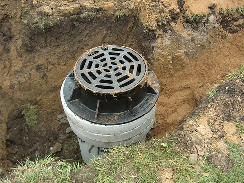
Metal Manhole Frame with concrete rings

Manhole Frame Demo

We also sat through a demo of a new type of frame and adustment system for manholes. This company was out of Canada, and their product is made entirely of rubber. Of course, being a conservative engineer, I am always skeptical at first with new products. Sometimes I find something new that does look worth trying. But in this case, I was mainly turned off by the cost. Purchasing the frame and adjusting rings was almost the same cost as buying a whole new manhole structure with the metal frame and concrete adjusting rings like the one shown in this photo. So it would be hard to justify. Plus it looked like the installation could be time-consuming which might make the total construction cost even more. It's still good to evaluate new products just to make sure we are making the best use of our funds.

Share

Using Unity3D to Simulate a City

Most of my exploration of virtual worlds for engineering has been in Second Life and OpenSim. However, this year I have been looking more at Unity3D. Engineers are conservative and seem to dismiss virtual worlds like Second Life and OpenSim. Even though these programs are 3D modeling tools, they don't resemble nor do they use the typical CAD tools engineers are used to working with. Because Unity3D works well with these CAD tools and better resembles modeling programs, I suspect it will find greater acceptance by AEC groups.

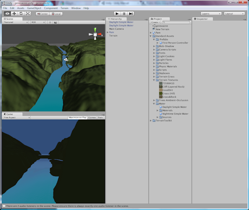
As an example of what can be done with Unity3D, I show below a crude example of importing DEM files into Unity3D. While the process is fairly easy, I still have some issues with the elevations looking too exaggerated, and there is an area that does not have contours. I also need to figure out how to apply the aerial images to the ground. So I still have a lot of work to do to refine this, but I thought it was pretty cool to be able to import contours and see the flat land transform immediately to reflect the topology of my city. I put some water in the model to indicate the river which helps to highlight the dam and islands. But I have yet to add any buildings, trees, or other features.

 Fox River Valley in Geneva, Ill.


Screenshot from Unity3D of Fox Valley River Valley through Geneva, Ill.


Another cool aspect of Unity3D is it can be embedded in a browser. Below is the static representation of what I created showing a view looking north through the river valley. Eventually I can add the capability for someone to travel through this model of my city with an avatar.

[WP_UnityObject src="http://www.publicworksgroup.com/images/stories/test1.unity3d" /]

Share

Boots on the Ground: Building a GIS, Part 1

Introduction
I started building a GIS for my last employer in 1993. Because it was a part-time endeavor, we did not even get close to what I consider a full implementation by 2009. But I can say we at least had a GIS with some geo-referenced, verified data that could be used by all departments in the city.

Through it all I gained a good, first-hand knowledge of the challenges faced by each community undertaking this journey. So for some time I have wanted to share with you some down-to-earth insights and ideas. If you are an experienced GIS user, I would be very interested in hearing how your ideas or experience compares to mine and in having you share your insights. And if you are just beginning, I hope this helps to encourage you to begin and offers some basic guidance.

A Little GIS History
Drafting RoomEven though GIS has been around for decades in one form or another, there still seems to be a general misunderstanding and an awkward handling of this technology. In government and in particular in the engineering field GIS seemed to creep up onto unsuspecting drafting personnel. Just as they were getting used to making the transition from drawing with pen and paper to CAD, this new beast called GIS emerged.

CAD StationMoving to CAD had really only required the need to learn a new set of tools. And while this did have somewhat of a learning curve, at least the process and product was familiar. The information brought in by the survey crew remained the same: points, elevations, etc. The drawing format remained the same using the typical plan and profile format. Even maps were produced in the same style and format.

GIS on the other hand at first seemed to be from the realm of the planning department with initial uses focusing on zoning, corporate boundaries, land use, and parcel information. Perhaps this is why in many agencies GIS emerged from planning and has even remained under this department’s oversight.

So even though mapping seemed to always be grounded firmly in engineering, staff in some engineering departments did not initially embrace this new method of cranking out maps. A general lack of knowledge and awareness about GIS coupled with the need to learn yet another tool and the added challenge of changing an approach to how information is collected, presented, and maintained created too big of a leap.

However some engineering departments successfully made this transition because they realized early on the benefit of using this technology instead of CAD to represent utility information for water, sewer, electric, etc. And by now most engineering departments share this approach. But, the distinct difference in the drawing styles, delivery, and philosophy behind CAD and GIS remains, and this is where I believe the awkward handling of GIS in an organization begins.

This confusion and misunderstanding affects where GIS is located within an organization. While the engineering department has traditionally been the government office charged with map production, a quick survey of where GIS hangs its hat in each agency will reveal a variety of locations including engineering, planning, community development, IT, emergency response, police, fire, and even in a department completely on its own.

Another aspect of all this is the wide variety of GIS implementation between agencies across the U.S. Some are GIS rich with a wide range of data all geo-referenced, verified, and available to the public while others are GIS poor with little to even no GIS data available, collected, or offered. And there are many that would fit anywhere in between these two extremes.

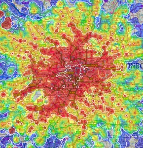
Multimodal Map of LondonWhy is this important to all of us? The awkward organization of GIS within an agency and the wide disparity of implementation? Because the world is fast moving beyond CAD and GIS into the next phase of information management. Those who haven’t figured GIS out or even worse, those who haven’t even begun are going to fall further behind. This difference in knowledge handling can be compared to one community having all dirt roads and another having interstate highways. And just as road conditions can affect growth and economic development so can the state of a community’s knowledge base.

Look for the next in this series: Starting to Build a Local Government GIS

Share

Why Do Social Networks Hate My Avatar?

Ok, I am really starting to get a complex about my avatar. For the second time this year, I have tried to join a social/business network and been told by the administrator that they don’t let people stay in their network unless a “real” photo is used in the profile. In other words, “No Avatars Allowed.” The network this time is a CAD-related ning network named Space Claiming.

Pam Broviak\'s Avatar - Banned for being non-real
Pam Broviak's Avatar - Banned for being non-real

Because I already have blogged about “avatar discrimination” here, I will not go into all that again. But each time this happens, I cannot help but wonder why the network administrator makes this decision. Are they so superficial that they need to actually see what someone looks like in order to adequately judge if someone is worthy of being admitted into their special group. They certainly cannot think I am nonhuman – I post blogs, upload photos, comment on other’s posts, respond to messages. Maybe they hate the way my avatar looks. All of these thoughts go through my mind, and then I realize if someone can only accept my contributions if they can see what I look like, then I probably don’t want to be part of that group anyway. It is kind of like what happens in high school, but I never thought 28 years after graduation, I would still be dealing with that mentality.

Maybe next time, I will just upload a photo of my crazy Aunt Sophie – God rest her soul. Would network administrators prefer this because it is real?

My crazy Aunt Sophie (now deceased).
My Aunt Sophie (now deceased).

Share

Designers in Second Life Unite!

Theory Shaw and Keystone Bouchard, along with many other designers using Second Life, have been pushing for an import/export tool in the Second Life client that would allow us to easily bring designs into and out of the Second Life environment. Theory has set up a request for this feature on the JIRA site. Read more about this on Keystone’s blog and follow his link to the JIRA site to vote for this feature.

Frankly I am surprised that this issue wasn’t front and center for the developers when they created the software. They obviously set up building tools allowing for a fairly precise coordinate system – how could they not have thought someone would want to import or export 3-D drawings and objects?

I listened to the comments made by Mitch Kapor at the closing session of the 5th birthday party for Second Life and came away with the idea that Linden Lab supports everyone’s efforts to present Second Life as a choice for delivering serious business solutions. Those of us already in Second Life are excited about using the software in this manner because we see the potential – we want to tell the world about it and look forward to the day the design community becomes fully immersed in this new virtual world. But we also realize the tools need a little more work for this to happen because our industry has such a conservative approach to adopting new technology.

So it’s up to us – use your vote to tell Mitch and the crew at Linden Lab that our industry needs this tool if they want us to be successful in promoting Second Life as a serious business application for planning, design, and construction. VOTE!

Share