Bike Repair Stations

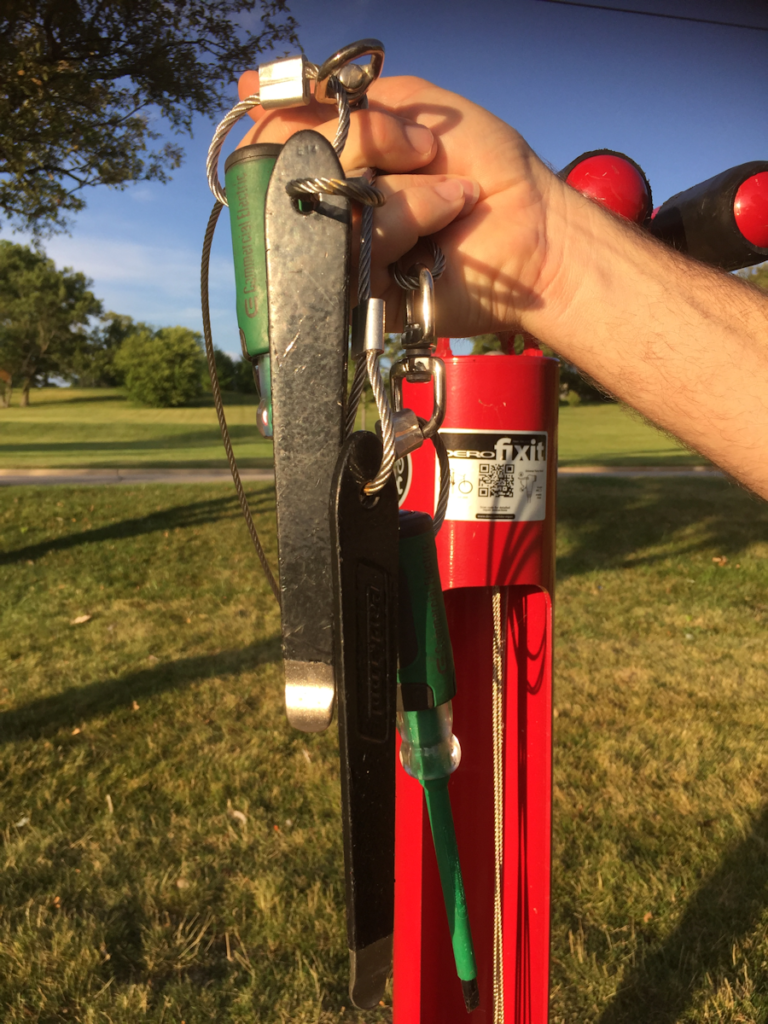
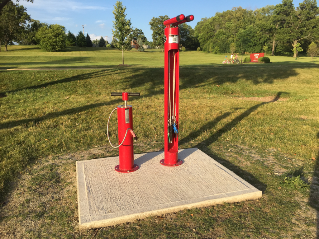
Bike Repair StationFortunately for bicyclists, public agencies are not only installing more bike trails, lanes, and shared use paths. Over the last few years many are also recognizing the need for support facilities and adding bike repair stations along these routes. The Fixit station shown in the photo above has an air pump to the left and a bike mounting/repair station on the right. This specific type of station includes the following tools which hang inside the station to assist in repairing your bike – a close up of these tools is shown below: Bike Repair StationTools

  • Philips and flat head screwdrivers
  • 2.5, 3, 4, 5, 6, 8mm Allen wrenches
  • 8, 9, 10, 11, 15, 32mm box wrenches
  • Tire levers (2)

This specific model, made and sold by Dero, is available in three styles and in many different colors and finishes including galvanized, thermoplastic, and powder coated. Their website offers CAD drawings, specifications, and other information. The company also publishes a map showing where their stations have been installed which might be helpful to bicyclists who are planning their routes. According to the map, bike repair stations have been placed in North and South America, Europe, Australia, and New Zealand. The company also offers other useful bicycle support structures such as shelters, lockers, racks, and signage.

Some agencies such as the Ventura County Fire Department (VCFD) have adopted an innovative idea of installing these stations at their own facilities. VCFD is taking advantage of National Bike Month to launch the installation of 16 repair stations at fire stations across the county. And they are hosting a Bike 'n' Ride event to celebrate. You can read more about the department's innovative support of their cycling community in this article in the Camarillo Acorn: "Fire stations across county to add bike repair services."

Share

Using Stationary Bikes to Design Bike Trails

Stationary Bike ScreenAs I ride my bike through some of the grades, curves, and alignments along the bike paths in my area, I often wonder if the person who designed them rides a bike. Because I can't imagine anyone who rides regularly making some of the design choices I encounter. This got me wondering if the designer would have still made those same choices if they had to first ride their design before building it. Of course, up until recently this really would not have been possible. But thanks to newer technologies, this type of design tool could probably be implemented today, and here's how I'm thinking it could be done.

Let's say I am given a project with the goal of designing a bike facility. This route could consist of a shared use path or an on-road facility or a combination of both. I would begin with a fairly traditional approach of analyzing potential alignments. Then after choosing one or more proposed routes, I would arrange to have these alignments surveyed, bring them into a CADD program like Autodesk Civil 3D, and start developing my design for each alternative. At this point, the final alternative would be chosen by analyzing the route for impacts, costs, public opinion, access to specific destinations, property acquisition issues, and other typical factors we usually consider when finalizing a design. The downside of this approach is that the actual performance of the facility can never be assessed. It is just assumed that if the engineer followed the same design criteria for each alternative, they would all perform in a similar manner. However, based on specific environmental conditions or design choices, this might not necessarily be true. Then it is not until the route is built and the money is spent that the users realize there are some issues with the design. So how can we use newer technologies to overcome this inability to assess our design before actually building it?

During the stage in which we analyze the alternatives, we could export a 3D model of our design. Then we could upload it to a stationary bicycle that has a screen display of our route. The computer on the bike would then pick up the design parameters such as slopes, lengths of segments, curves, etc., and then program the bike to react to those parameters. So if I have designed too steep of a slope for too long of a distance, it will become very obvious as I actually bike that route. And while this could be done simply to analyze only the design of the path, other models such as terrain, trees, intersections, and buildings along with environmental conditions such as wind, sunlight, and perhaps even traffic flow could also be added to allow for a more detailed analysis of how the environment impacts the path. In addition to having the engineer bike their own design, potential users of the path who span a whole range of abilities could also bike the design and offer input and comments.

So how close are we to being able to do this? I suppose that is a question for the companies manufacturing stationary bicycles. I know they can take a route and project it on the screen as you can see in the photo at the beginning of this post. And I know they can adjust the bike for grade/resistance. But can they read essentially what would be metadata about the images being displayed and use that to control the grade? I don't know with the current bikes, but I am sure if it's not possible now, it could definitely be programmed to function in this manner. As for exporting a file from Civil 3D that could integrate with a stationary bike in this manner, I would think based on how innovative Autodesk has always been that company would have no problem figuring this out.

And even though my main thought in all this was to help us design better bike facilities, it also made me wonder if something like this could lead to a whole new industry for civil engineers in which we design virtual bike experiences for stationary bikes too! 


Share

Improving Bicycle Path Design

Over the last year or so we've logged significant mileage on our bikes. While one outcome has been the expected increase in personal fitness, another has been better awareness and insight into design of bicycle facilities. Most of the paths along which we ride have been in place for many years so were probably designed under older guidance, but I am still not sure that all of the issues we've noticed have yet been addressed by more recent bicycle design manuals. So I wanted to share a few of the problem areas we have identified to see if anyone else has figured out or has any comments for some best practices or guidance to improve these aspects of design:

Tree impacts to the path
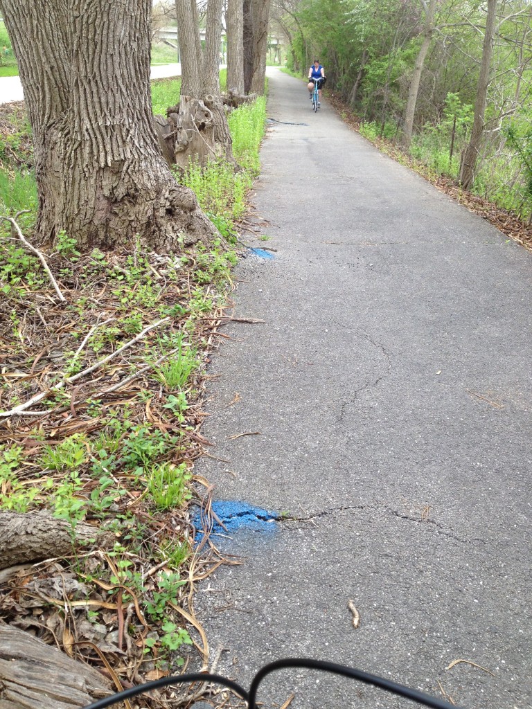
Root Damage on Bike Path

A lot of off-road paths are lined by trees. This can create a few issues that could cause a cyclist to fall and possibly be injured. This can occur in the colder climates because trees drop leaves that can pile up and become slippery if not cleared. Trees also drop seeds such as acorns or walnuts. Hitting these the wrong way could cause a cyclist to lose balance and fall. I know of at least one agency that regularly sends out a small sweeper about once a week to clear debris, particularly in the fall and that maintenance activity appears to keep the path in that area fairly clear.

Trees can also cause damage to the path from roots. As you can see in the photo here, someone has marked areas of the path where trees have caused the path to heave. If a cyclist did not see these bumps, they could lose balance and fall.

The tree's proximity to the path can also cause a potential for problems. As shown in the photo, trees are often located very close to the pavement. If too close, the trunks of the trees can also grow into the pavement. One day when we were riding in another area of this trail, we saw a cyclist miss navigating a curve and hit a tree that was very close to the path. He fell and fortunately was not hurt. But it made us wonder if there should be a clear zone for bike paths similar to the concept used for roadway design. The Washington State Shared-Use Path Design Manual does call for a horizontal clearance of two feet (page 1515-5). 

Roadway approaches

A lot of the trails we ride follow a river so quite often we end up having to navigate steep slopes when the path changes course away from the river. There have been a few instances where it seemed the designer could have mitigated the slope by lengthening out the transition, but instead took the shorter route which resulted in a slope almost steep enough to require us to dismount and walk our bikes. We've also wondered why when a bike route we follow is moved onto streets, the steepest street in the area is chosen for the route. One of the roads we ride along is so steep we definitely have to get off our bikes and walk them a block or two until the route turns down another, flatter street. I realize the calculation for bike level of service does not take into account grade – probably because it was developed in Florida along flat routes – but if I have to get off my bike, I am no longer able to use it as a bike route which would seem to mean a complete failure of that bike facility. So I definitely believe grade should be incorporated into the Bike LOS calculation. 

The other problem with steep slopes is that they require a lot of energy and momentum to ride up. And because many paths we bike along seem to have been designed with a steep slope immediately adjacent to an intersection with a road, we end up going up the slope approaching the road at a high rate of speed and with a lot of momentum then have to slam on the brakes immediately as we hit the road. I always wonder how we appear to the cars that are approaching the crossing. I would think it looks like we are not going to stop. The other problem with this design is there is usually no flat area at the top of slope at the road intersection. So as you wait for the cars to go by, you are sitting on that steep slope which makes it even more difficult to start moving again and quickly pedal across the road. A better design would seem to be to pull back the slope slightly and allow for a flatter area at the top where the path intersects the road. The question would be what distance would work best here? Another consideration would perhaps be to give a widened area at these intersections to allow for several users to queue while they wait to cross.

The other area where slopes seem to cause problems is at stream crossings. On the paths where we ride, there are many of these crossings and usually the downgrade is very steep on both sides of the bridge. So the ideal approach would be to ride fast down the hill and across the bridge so we have enough momentum to assist in making it up the hill on the other side. Unfortunately most of the designs have brought the slope down almost to a "V" at the edge of the bridge instead of designing in a gradual vertical curve. And because the joint where the asphalt path meets the bridge is not always smooth, we end up having to reduce our speed to make it over this severe change in grade that might also have a bump. So the only distance we have to build up speed again is across the short bridge which usually isn't enough.

Sight distance

It seems that there is some guidance out there for sight distance, but that doesn't help riders on paths that were built with no thought to this design consideration. Perhaps on older facilities, agencies responsible for the paths could go back and assess their facility and add in striping or signs to let cyclists know there are potential sight distance problems in a specific area.


Adjacent surfaces

Surface material of areas adjacent to bike paths can cause damage to the path or unsafe conditions for users of the path. For example, one trail we ride is located next to a gravel parking lot near a school. After riding through here a few times, we've gotten to the point where we now remain in the road through this section because there is always a lot of gravel on the path. This appears to be due to the drainage design and grades of the road, lot, and path in this location. As water flows from the road and across the lot, it picks up gravel from the parking lot. Then as the water flows across the path, the gravel drops out onto the asphalt, possibly because the path looks like it could be a localized low area. The gravel on the path is difficult to ride over and can cause instability to a cyclist which can result in them falling and possibly getting injured.
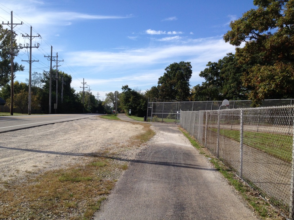
Gravel along bike path

Path Material

Path material is definitely an important component of a bike path. There is a path we ride along, or I should say used to ride along, where the agency decided to place asphalt grindings over the crushed gravel that was initially placed as the surface. Grindings are definitely a material that should never be used for a shared used path or even a dedicated bike path. There are usually few fines in it unless it has been processed to have fines added which usually isn't the case. So riding along a path made with grindings ends up somewhat similar to the experience of riding on marbles. We also came across another path where an agency had placed sand. Riding in sand is also not very easy. So as you can see in the photo below, people appear to avoid it by walking their bikes through the grass which is exactly what we did. The FHWA provides some guidance on surface materials for shared-use paths as part of their Designing Sidewalks and Trails for Access Part II of II: Best Practices Design Guide.
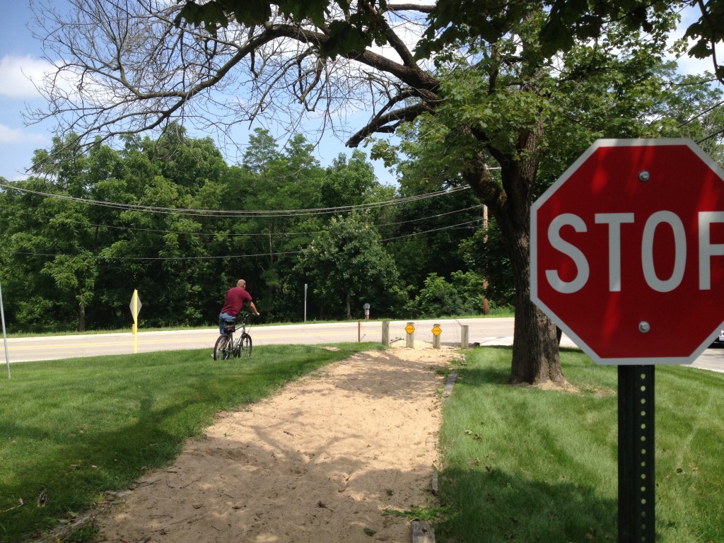
Bike Path with Sand


Signage
 
Another issue we noticed along many bike paths is a lack of directional signage. One day last year, I decided to go on a 30+ mile bike ride that took me along many routes with which I was not familiar. One particular route required me to transition between trail and roadway several times. Unfortunately it was difficult to navigate using my phone since it was having battery issues and didn't make it through most of the trip leaving me stranded with no map. Fortunately there was another cyclist who knew exactly where to go to get off one trail, make our way through a maze of streets and connecting trails and manage to end up where two main trails picked up again. And he was nice enough to realize I was lost and needed his guidance. Just a few well placed signs would have really helped me find my way because I really can't go biking on a regular basis hoping there will be a nice person there who knows the way and will help.
 
 
Share

Infographic of the Month – September 2013

This month we have a bike-related infographic supplied by Online Masters in Public Health. Whether it's to improve health or save money, people seem to be hopping on their bikes more than ever. And cities and states are working to accommodate these increased demands for bicycle facilities. As the Infographic shows, one initiative experiencing great success throughout the U.S. is bike sharing.

An infographic by the team at Online Masters In Public Health

The Public Works Group tries to highlight at least one infographic a month related to any public works topic. So if you've got 'em, send 'em!

Share

Balancing – the key to a successful bike sharing program

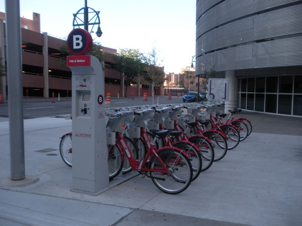
Bike Sharing Station in Denver ColoradoMost major cities have implemented some level of bike sharing programs in their community. And based on usage reports, these programs have shown to be well received by people in these communities. The idea behind the setup is fairly simple: install bike docking stations at key locations through a city and allow people to rent the bikes using self-pay kiosks. Users pick up the bikes from one station and deliver them to another near their destination. The result is a convenient and relatively low-cost transportation alternative that does not add to existing congestion levels. 

Setting up the program can be easier than planning and constructing more traditional infrastructure. They key is to determine station locations and number of docks/bikes per station depending on expected demand. Choosing a location where there is already room for a station such as along an existing sidewalk can also cut costs and installation times. For an optimum layout, it's also a good idea to plan stations in a manner similar to transit station layouts with a type of grid system that allows for pedestrian trips less than 10 to 15 minutes. All of this is probably fairly obvious to transportation professionals. But as with most public works services, the critical, and sometimes unforseen, component is in the operations. In bike sharing, the success of the service relies on the ability to manage the number of bikes at each station.

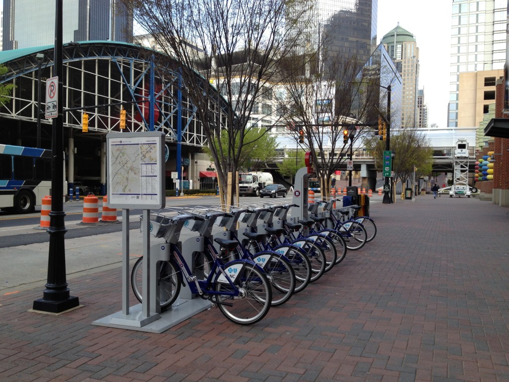
Bike sharing station in Charlotte, NC

The service level for users diminishes when no bikes are available to meet demands. And this is also true when users cannot find spaces to return bikes at stations near their destinations. This operational challenge has been studied in several papers. One more recently released paper, Dynamic vehicle redistribution and online price incentives in shared mobility systems indicates the main costs of operations, which have been reported at $1,200 to $1,944 per bike annually, are also dependent on this need to balance the number of bikes between stations. Following is an excerpt from the report:

"One of the major contributors to operational costs is the need to operate staffed trucks for manual relocation of bicycles, in order to balance the difference between supply and demand at various stations. If this effort were not made, the arrival and departure of customers would cause many stations to run full or empty, and the customer service rate would drop below acceptable levels."

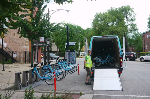
So to run well throughout the day, the program relies on an operator and staff to constantly monitor the number of bikes at each station and pick up and deliver bikes as needed between them. Below is a photo showing a van peforming this pickup/delivery for the Divvy bike sharing system in Chicago (Source: Steven Vance, Flickr).

Divvy on launch day: Rebalancing;

And to cut costs, some studies have suggested offering incentives to riders for delivering bikes where they are most needed. This would seem simple to implement because many stations and systems are digitally monitored. So users can easily determine the number of bikes at a station using apps such as CycleFinder. Incentives could be offered once a station hits a certain level and then trigger the app to display an icon through these programs alerting users to the incentive. Some studies have suggested that incentives could eliminate the need to manually balance bikes on the weekend. However, during the week when there is heavy commuter use, manual balancing would still need to take place.


For those interested in learning more about bike sharing programs, here are some additional resources and information:

BICYCLE-SHARING SCHEMES: ENHANCING SUSTAINABLE MOBILITY IN URBAN AREAS, UNITED NATIONS DEPARTMENT OF ECONOMIC AND SOCIAL AFFAIRS, May 2011

Global Bike Share Map, also showing real time usage

The Bike-Sharing World Map


Share